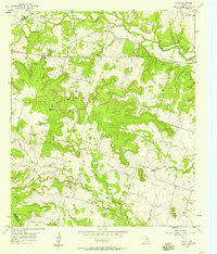
1954 Map of Pearl
USGS Topo · Published 1957About this map
Pearl and Bee House serve as the primary nodes of settlement in this central Texas landscape, where the plateaus of the Edwards Plateau transition into dissected creek valleys. The drainage patterns of Cowhouse Creek and its tributaries, such as North Bee House Creek and Bullard Creek, dictate the placement of early roads and homesteads. Local family names and geography are etched into the terrain at Fletchers Point and Wayback Mountain, while several springs like Whiteleather Spring and Old Cottonwood Spring underscore the importance of water sources in this environment. Significant landmarks include the Twin Mountain peaks and the crossing at Cromleans near the Lampasas County line. Evidence of local industry is present through scattered extraction sites, including a Rock Quarry and various Caliche Pits, while a prominent Pipe Line cuts across the southeastern quadrant, marking modern infrastructure development amidst the traditional ranching landscape.
Find a feature on this map
25 named features on this map. Tap any name to fly to it.
Don’t see what you’re looking for? This feature index may not catch every label — zoom into the map to look around manually.
Map Details
Editions of this 1954 Pearl Map
This is the sole edition of this map. No revisions or reprints were ever made.
Other maps of this area

1887 · Lampasas
USGS Topo · 1:125,000

1888 · Hamilton
USGS Topo · 1:125,000

1888 · Meridian
USGS Topo · 1:125,000

1894 · Hamilton
USGS Topo · 1:125,000

1894 · Meridian
USGS Topo · 1:125,000

1894 · Lampasas
USGS Topo · 1:125,000

1894 · Gatesville
USGS Topo · 1:125,000

1947 · Purmela
USGS Topo · 1:62,500

1947 · Pidcoke
USGS Topo · 1:24,000

1947 · Purmela
USGS Topo · 1:24,000