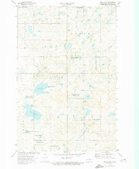
1972 Map of Pearl Lake
USGS Topo · Published 1974About this map
Pearl Lake and Mud Lake anchor this 1970s landscape in Stutsman County, defined by the glacial pothole topography of central North Dakota. The area is heavily managed for conservation, with numerous tracts of the National Waterfowl Production Area scattered across the prairie. The Burlington Northern railroad cuts through the northwestern corner of the quadrangle, serving as a primary transit corridor through the township. The map reveals a sparsely populated agricultural region where local industry is limited to scattered Gravel Pits, and communication infrastructure is marked by prominent Radio Towers. This survey provides a meticulous record of the natural depressions and marshlands that characterize the Missouri Coteau, before many smaller wetlands were further altered by modern land use.
Find a feature on this map
12 named features on this map. Tap any name to fly to it.
Don’t see what you’re looking for? This feature index may not catch every label — zoom into the map to look around manually.
Map Details
Editions of this 1972 Pearl Lake Map
2 editions found
Other maps of this area

1952 · New Rockford
USGS Topo · 1:250,000

1953 · Jamestown
USGS Topo · 1:250,000

1954 · Cleveland NW
USGS Topo · 1:24,000

1954 · Medina
USGS Topo · 1:24,000

1955 · Crystal Springs
USGS Topo · 1:24,000

1956 · New Rockford
USGS Topo · 1:250,000

1956 · Jamestown
USGS Topo · 1:250,000
1958 · Goldwin SW
USGS Topo · 1:24,000

1958 · Goldwin
USGS Topo · 1:24,000

1971 · New Rockford
USGS Topo · 1:250,000