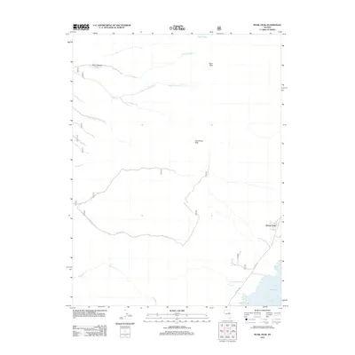
2012 Map of Pearl Peak
USGS Topo · Published 2012About this map
Pearl Peak and Cass House Peak dominate this high-elevation landscape in Elko County, defining a rugged watershed where numerous forks and creeks descend toward the valley floor. The small settlement of Shanty Town sits on the eastern edge of the quadrangle, accessible via CO Hwy-788, representing one of the few human outposts in this wilderness. The terrain is characterized by a complex drainage system, including the various branches of Lindsay Cr and Mitchell Cr which carve through deep incisions like Rocky Canyon. Water sources are vital features here, marked by remote points like Pearl Lake, Flyn Spring, and the curiously named Y Pond. This 2012 survey illustrates the intersection of high-desert hydrology and isolated settlement, providing a detailed record of the springs and seasonal watercourses that sustain life in this corner of Nevada.
Find a feature on this map
18 named features on this map. Tap any name to fly to it.
Don’t see what you’re looking for? This feature index may not catch every label — zoom into the map to look around manually.
Map Details
Editions of this 2012 Pearl Peak Map
This is the sole edition of this map. No revisions or reprints were ever made.
Other maps of this area

1934 · Jiggs
USGS Topo · 1:125,000

1937 · Jiggs
USGS Topo · 1:125,000

1955 · Elko
USGS Topo · 1:250,000

1958 · Elko
USGS Topo · 1:250,000

1959 · Jiggs
USGS Topo · 1:62,500

1959 · Sherman Mtn
USGS Topo · 1:62,500

1962 · Elko
USGS Topo · 1:250,000

1965 · Elko
USGS Topo · 1:250,000

1968 · Franklin Lake SW
USGS Topo · 1:24,000
1968 · Ruby Lake NW
USGS Topo · 1:24,000