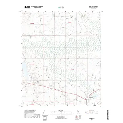
2018 Map of Pearl River
USGS Topo · Published 2018About this map
The Pearl River basin dominates this Neshoba County landscape, showing a complex network of wetlands and tributaries that have long shaped local development. Near the southern edge of the survey, the communities of Williamsville and Fairview sit adjacent to major transportation corridors, while the Philadelphia Municipal Airport occupies the eastern margin. The map is particularly dense with small family and community burial grounds, including Henrys Chapel Cem, Black Jack Cem, and McNeill Cem, offering significant data for genealogical research in the area.
Find a feature on this map
89 named features on this map. Tap any name to fly to it.
Don’t see what you’re looking for? This feature index may not catch every label — zoom into the map to look around manually.
Map Details
Editions of this 2018 Pearl River Map
This is the sole edition of this map. No revisions or reprints were ever made.
Other maps of this area

1953 · Meridian
USGS Topo · 1:250,000

1957 · Meridian
USGS Topo · 1:250,000

1962 · Edinburg
USGS Topo · 1:62,500

1965 · Meridian
USGS Topo · 1:250,000

1972 · Pearl River
USGS Topo · 1:24,000

1972 · Plattsburg
USGS Topo · 1:24,000
1972 · Noxapater
USGS Topo · 1:24,000

1972 · Deemer
USGS Topo · 1:24,000
1972 · Philadelphia
USGS Topo · 1:24,000

1972 · Madden
USGS Topo · 1:24,000