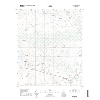
2020 Map of Pearl River
USGS Topo · Published 2020About this map
The Pearl River and its expansive wetlands dominate this landscape just west of Philadelphia, Mississippi. The river's winding course is mirrored by its tributary, Jofuska Creek, and the engineered drainage of the Kentawka Canal to the south. This 2020 survey illustrates a region defined by its water systems and the rural infrastructure of Neshoba County. To the north, Marty Stuart Dr skirts the headwaters of Finishook Cr, while several local burial grounds, including Old Pearl Valley Cem and Henrys Chapel Cem, are preserved in the surrounding hills. The map captures the western edge of Philadelphia, showing the proximity of the Philadelphia Municipal Airport and the East Central Community College Integrated Technologies Training Center to the lowlands of Mud Lake. Further south, the community of Williamsville sits at a crossroads near where Wolf Cr flows toward the primary river channel.
Find a feature on this map
85 named features on this map. Tap any name to fly to it.
Don’t see what you’re looking for? This feature index may not catch every label — zoom into the map to look around manually.
Map Details
Editions of this 2020 Pearl River Map
This is the sole edition of this map. No revisions or reprints were ever made.
Other maps of this area

1953 · Meridian
USGS Topo · 1:250,000

1957 · Meridian
USGS Topo · 1:250,000

1962 · Edinburg
USGS Topo · 1:62,500

1965 · Meridian
USGS Topo · 1:250,000

1972 · Pearl River
USGS Topo · 1:24,000

1972 · Plattsburg
USGS Topo · 1:24,000
1972 · Noxapater
USGS Topo · 1:24,000

1972 · Deemer
USGS Topo · 1:24,000
1972 · Philadelphia
USGS Topo · 1:24,000

1972 · Madden
USGS Topo · 1:24,000