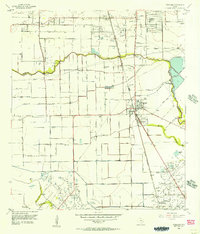
1955 Map of Pearland
USGS Topo · Published 1957About this map
Pearland stands as the primary hub of this Texas coastal plain landscape during the mid-1950s, a period marked by burgeoning petroleum production and early suburban growth. The map illustrates a region in transition, where established rural sites like Clear Creek Farm and Minnetex exist alongside the developing Skyscraper Shadows subdivision. Industrial activity is concentrated at the Mykawa Oil Field and the Manvel Field, while the Gulf Colorado and Santa Fe railroad tracks cut a diagonal path through the terrain, connecting Pearland to the shipping siding at Hastings.
Find a feature on this map
29 named features on this map. Tap any name to fly to it.
Don’t see what you’re looking for? This feature index may not catch every label — zoom into the map to look around manually.
Map Details
Editions of this 1955 Pearland Map
2 editions found
Other maps of this area

1915 · Bellaire
USGS Topo · 1:24,000

1915 · Park Place
USGS Topo · 1:24,000

1915 · Deepwater
USGS Topo · 1:24,000

1916 · Genoa
USGS Topo · 1:24,000

1919 · Deepwater
USGS Topo · 1:31,680

1920 · Genoa
USGS Topo · 1:31,680

1920 · Mykawa
USGS Topo · 1:31,680

1920 · Almeda
USGS Topo · 1:31,680

1921 · Bellaire
USGS Topo · 1:31,680

1922 · Park Place
USGS Topo · 1:31,680