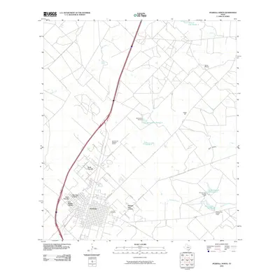
2010 Map of Pearsall North
USGS Topo · Published 2010About this map
Pearsall and its expanding residential clusters anchor this South Texas landscape in 2010. The map details the growth of distinct neighborhoods such as Alta Vista Colonia, Frio Heights Colonia, and Pearsall East Colonia, which stand in contrast to the surrounding ranching and agricultural acreage. To the north, the Agricultural Supplies Airport points to the specialized infrastructure supporting the local economy. The terrain is marked by family-named landmarks and essential water management features, including Jones Mound, Abbey Hill, and a series of reservoirs along Buckhorn Creek known as the Morrow Lakes. Local history is grounded at the Pearsall Cemetery, while the road network shows the importance of the Interstate 35 corridor, flanked by routes like Cherry Ranch Rd and Armadillo Rd that reach into the brush country.
Find a feature on this map
42 named features on this map. Tap any name to fly to it.
Don’t see what you’re looking for? This feature index may not catch every label — zoom into the map to look around manually.
Map Details
Editions of this 2010 Pearsall North Map
This is the sole edition of this map. No revisions or reprints were ever made.
Other maps of this area

1925 · Pearsall 1-b
USGS Topo · 1:48,000

1925 · Pearsall 1-c
USGS Topo · 1:48,000

1927 · Pearsall
USGS Topo · 1:62,500

1934 · Schattel
USGS Topo · 1:62,500

1942 · Natalia
USGS Topo · 1:62,500

1953 · Crystal City
USGS Topo · 1:250,000

1954 · San Antonio
USGS Topo · 1:250,000

1955 · Crystal City
USGS Topo · 1:250,000

1957 · San Antonio
USGS Topo · 1:250,000

1961 · Crystal City
USGS Topo · 1:250,000
Featured Places
- Pearsall, TX
- West Pearsall, Pearsall
- North Pearsall, TX
- Pearsall East Colonia, TX
- Alta Vista Colonia, Pearsall