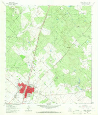
1964 Map of Pearsall North
USGS Topo · Published 1966About this map
The city of Pearsall serves as the focal point of this mid-1960s study, showing a concentrated grid of residential and civic development including the Westside Sch, Jr High Sch, and the local Hospital. The town's economy and physical layout are defined by the Missouri Pacific railroad line which cuts diagonally through the landscape, alongside industry-focused sites like the Gravel Pits and various municipal services.
Find a feature on this map
29 named features on this map. Tap any name to fly to it.
Don’t see what you’re looking for? This feature index may not catch every label — zoom into the map to look around manually.
Map Details
Editions of this 1964 Pearsall North Map
2 editions found
Other maps of this area

1925 · Pearsall 1-b
USGS Topo · 1:48,000

1925 · Pearsall 1-c
USGS Topo · 1:48,000

1927 · Pearsall
USGS Topo · 1:62,500

1934 · Schattel
USGS Topo · 1:62,500

1942 · Natalia
USGS Topo · 1:62,500

1953 · Crystal City
USGS Topo · 1:250,000

1954 · San Antonio
USGS Topo · 1:250,000

1955 · Crystal City
USGS Topo · 1:250,000

1957 · San Antonio
USGS Topo · 1:250,000

1961 · Crystal City
USGS Topo · 1:250,000
Featured Places
- Pearsall, TX
- Pearsall East Colonia, TX
- North Pearsall, TX
- Alta Vista Colonia, Pearsall
- West Pearsall, Pearsall