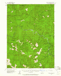
1954 Map of Pearsoll Peak
USGS Topo · Published 1961About this map
The Siskiyou National Forest dominates this mid-century landscape along the boundary of Curry and Josephine counties. High-elevation lookouts and shelters define the backcountry infrastructure of the era, including the Silver Peak Lookout and the Pine Creek Shelter. The rugged network of drainages feeding the Illinois River and South Fork Illinois River reveals a history of resource extraction, evidenced by several dispersed mining operations. Prospectors and geologists can trace the locations of the Old Glory Mine, Chrome King Mine, and the Uncle Sam Mine tucked into the steep drainages. Remote homesteads like Fantz Ranch and McCaleb Ranch suggest the isolation of these mountain holdings, while the Siskiyou Trail and Tincup Pass provided critical transit across the divide near Pearsoll Peak.
Find a feature on this map
108 named features on this map. Tap any name to fly to it.
Don’t see what you’re looking for? This feature index may not catch every label — zoom into the map to look around manually.
Map Details
Editions of this 1954 Pearsoll Peak Map
4 editions found

Other maps of this area

1899 · Port Orford
USGS Topo · 1:125,000

1903 · Port Orford
USGS Topo · 1:125,000

1917 · Kerby
USGS Topo · 1:125,000

1918 · Kerby
USGS Topo · 1:125,000

1945 · Kerby
USGS Topo · 1:125,000

1946 · Galice
USGS Topo · 1:62,500

1948 · Galice
USGS Topo · 1:62,500

1954 · Coos Bay
USGS Topo · 1:250,000

1954 · Cave Junction
USGS Topo · 1:62,500

1954 · Marial
USGS Topo · 1:62,500