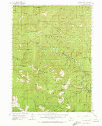
1954 Map of Pearsoll Peak
USGS Topo · Published 1972About this map
The Siskiyou Mountains define the character of this mid-century survey along the border of Curry and Josephine counties. Remote mining operations and isolated ranching outposts are the primary signs of habitation, with several extraction sites like the Old Glory Mine, Robertson Mine, and Chrome King Mine scattered across the high terrain. The drainage of the Illinois River serves as the central artery for the landscape, marked by river mile indicators and rugged tributaries including Indigo Creek and Briggs Creek. Land use is further evidenced by a network of lookouts and administrative sites, from the Silver Peak Lookout to the Store Gulch Guard Station. Named prairies and flats, such as Silver Prairie and Sourdough Flat, break the mountain peaks, suggesting areas of historical grazing or small-scale settlement like the Fantz Ranch and McCaleb Ranch.
Find a feature on this map
107 named features on this map. Tap any name to fly to it.
Don’t see what you’re looking for? This feature index may not catch every label — zoom into the map to look around manually.
Map Details
Editions of this 1954 Pearsoll Peak Map
4 editions found

Other maps of this area

1899 · Port Orford
USGS Topo · 1:125,000

1903 · Port Orford
USGS Topo · 1:125,000

1917 · Kerby
USGS Topo · 1:125,000

1918 · Kerby
USGS Topo · 1:125,000

1945 · Kerby
USGS Topo · 1:125,000

1946 · Galice
USGS Topo · 1:62,500

1948 · Galice
USGS Topo · 1:62,500

1954 · Coos Bay
USGS Topo · 1:250,000

1954 · Cave Junction
USGS Topo · 1:62,500

1954 · Marial
USGS Topo · 1:62,500