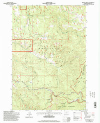
1995 Map of Pearson Ridge
USGS Topo · Published 1998About this map
Umatilla National Forest and the surrounding high country in eastern Oregon are meticulously documented in this mid-1990s survey. The landscape is defined by the steep drainage systems of Cable Creek and Hidaway Creek, showcasing a remote forest interior managed for both conservation and resource use. The presence of the Pearson Guard Station at the foot of Pearson Ridge highlights the administrative infrastructure of the era, while the expansive North Fork John Day Wilderness occupies the southeastern corner. This map details a complex network of recreational and administrative paths, including the uniquely named Woop-De-Doo Trail and the Switchback Trail, alongside seasonal watering points like White Pine Trough Spring and Weasel Spring. High-altitude openings such as Long Meadows and Roundaway Meadow provide contrast to the timbered slopes, marking this as a vital record of the Blue Mountains region.
Find a feature on this map
36 named features on this map. Tap any name to fly to it.
Don’t see what you’re looking for? This feature index may not catch every label — zoom into the map to look around manually.
Map Details
Editions of this 1995 Pearson Ridge Map
This is the sole edition of this map. No revisions or reprints were ever made.
Other maps of this area

1951 · Dale
USGS Topo · 1:62,500

1951 · Desolation Butte
USGS Topo · 1:62,500

1953 · Pendleton
USGS Topo · 1:250,000

1955 · Canyon City
USGS Topo · 1:250,000

1956 · Pendleton
USGS Topo · 1:250,000

1959 · Canyon City
USGS Topo · 1:250,000

1967 · Ukiah SE
USGS Topo · 1:24,000

1967 · Tower Mtn
USGS Topo · 1:24,000

1967 · Sullivan Gulch
USGS Topo · 1:24,000

1967 · Lehman Springs
USGS Topo · 1:24,000