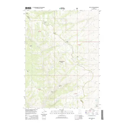
2017 Map of Peck Canyon
USGS Topo · Published 2017About this map
Cache National Forest land dominates this high-altitude section of the Wasatch Range, where the county line between Rich and Morgan Counties follows the drainage divides. The complex topography is defined by prominent elevations such as Wasatch Ridge and Condie Ridge, which separate a network of deep-cut drainage systems. These waterways, including Peck Canyon, Little Peck Canyon, and Bull Nelson Cr, carve through the landscape toward the eastern and southern edges of the sheet. Water management in this high-country environment is evidenced by the presence of Saleratus Reservoir Number 3 and Lake Hollow in the southeastern corner. The map captures a transition of terrain where name-rich canyons like Five Spring Canyon and Meachum Canyon serve as key identifiers for this otherwise uninhabited portion of northern Utah.
Find a feature on this map
26 named features on this map. Tap any name to fly to it.
Don’t see what you’re looking for? This feature index may not catch every label — zoom into the map to look around manually.
Map Details
Editions of this 2017 Peck Canyon Map
This is the sole edition of this map. No revisions or reprints were ever made.
Other maps of this area

1954 · Ogden
USGS Topo · 1:250,000

1958 · Ogden
USGS Topo · 1:250,000

1960 · Ogden
USGS Topo · 1:250,000

1964 · Lost Creek Dam
USGS Topo · 1:24,000

1964 · Francis Canyon
USGS Topo · 1:24,000

1968 · Horse Ridge
USGS Topo · 1:24,000

1968 · Dairy Ridge
USGS Topo · 1:24,000

1968 · Shearing Corral
USGS Topo · 1:24,000

1968 · Mc Kay Hollow
USGS Topo · 1:24,000

1968 · Meachum Ridge
USGS Topo · 1:24,000