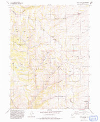
1991 Map of Peck Canyon
USGS Topo · Published 1991About this map
Cache National Forest encompasses the vast majority of this high-elevation terrain along the border of Rich and Morgan counties. The landscape is defined by a series of prominent divides, including Wasatch Ridge, Condie Ridge, and Blue Ridge, which separate deep canyons and seasonal drainages. Water is the primary driver of the local geography, with numerous named springs feeding into Beaver Creek, Lost Creek, and Bull Nelson Creek. The presence of Saleratus Reservoir No 3 and the Saleratus Creek drainage suggests the saline nature of the soil in the southeastern portion of the quadrangle. Aside from isolated infrastructure like a Drill Hole and a network of 4WD tracks, the area remains largely undeveloped, preserving the character of the northern Utah backcountry as it was surveyed in the late 20th century.
Find a feature on this map
20 named features on this map. Tap any name to fly to it.
Don’t see what you’re looking for? This feature index may not catch every label — zoom into the map to look around manually.
Map Details
Editions of this 1991 Peck Canyon Map
This is the sole edition of this map. No revisions or reprints were ever made.
Other maps of this area

1954 · Ogden
USGS Topo · 1:250,000

1958 · Ogden
USGS Topo · 1:250,000

1960 · Ogden
USGS Topo · 1:250,000

1964 · Lost Creek Dam
USGS Topo · 1:24,000

1964 · Francis Canyon
USGS Topo · 1:24,000

1968 · Horse Ridge
USGS Topo · 1:24,000

1968 · Dairy Ridge
USGS Topo · 1:24,000

1968 · Shearing Corral
USGS Topo · 1:24,000

1968 · Mc Kay Hollow
USGS Topo · 1:24,000

1968 · Meachum Ridge
USGS Topo · 1:24,000