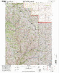
1998 Map of Peck Canyon
USGS Topo · Published 2000About this map
Cache National Forest defines the high-altitude landscape of this northern Utah survey, where the dividing line between Rich and Morgan Counties follows the crest of Wasatch Ridge. The map documents a rugged watershed characterized by numerous drainage systems, including Lost Creek, Beaver Creek, and the namesake Peck Canyon. For researchers of local land use, the presence of a Shearing Corral and the Saleratus Reservoir No 3 points to the area's history of high-country livestock management. Small seasonal waterways such as Sawmill Creek and Bull Nelson Creek feed into larger basins, while named elevations like Condie Ridge and Bee Ridge provide landmarks for navigating this roadless terrain. The detail here reveals the complex topography of the Ranger District in the late 20th century, highlighting a landscape shaped by water and high-elevation ranching.
Find a feature on this map
21 named features on this map. Tap any name to fly to it.
Don’t see what you’re looking for? This feature index may not catch every label — zoom into the map to look around manually.
Map Details
Editions of this 1998 Peck Canyon Map
This is the sole edition of this map. No revisions or reprints were ever made.
Other maps of this area

1954 · Ogden
USGS Topo · 1:250,000

1958 · Ogden
USGS Topo · 1:250,000

1960 · Ogden
USGS Topo · 1:250,000

1964 · Lost Creek Dam
USGS Topo · 1:24,000

1964 · Francis Canyon
USGS Topo · 1:24,000

1968 · Horse Ridge
USGS Topo · 1:24,000

1968 · Dairy Ridge
USGS Topo · 1:24,000

1968 · Shearing Corral
USGS Topo · 1:24,000

1968 · Mc Kay Hollow
USGS Topo · 1:24,000

1968 · Meachum Ridge
USGS Topo · 1:24,000