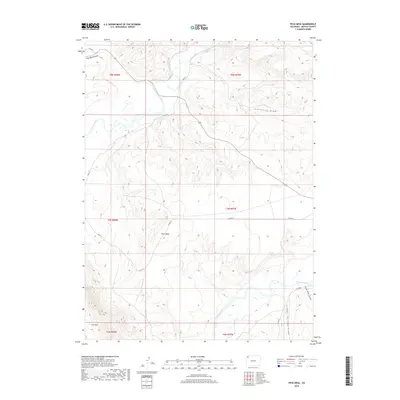
2019 Map of Peck Mesa
USGS Topo · Published 2019About this map
The confluence of high-desert waterways and complex topography defines this portion of Moffat County. The Little Snake River meanders across the northwestern corner, eventually joining the larger drainage system, while the Yampa River carves its path across the southern reaches. Elevated landforms such as Peck Mesa and the prominent Cross Mtn overlook a network of seasonal drainages, including East Boone Draw, Simsberry Draw, and Cedar Springs Draw. This landscape represents the arid, ranching-oriented character of northwest Colorado, where historical county roads like Co RD 10 and Co RD 215 provide the primary access through the townships. The map illustrates the intersection of Public Land Survey System boundaries, showing the alignment of t7n r97w and surrounding townships against the natural breaks of Lone Tree Gulch and the river basins.
Find a feature on this map
21 named features on this map. Tap any name to fly to it.
Don’t see what you’re looking for? This feature index may not catch every label — zoom into the map to look around manually.
Map Details
Editions of this 2019 Peck Mesa Map
This is the sole edition of this map. No revisions or reprints were ever made.
Other maps of this area

1907 · White River
USGS Topo · 1:125,000

1910 · White River
USGS Topo · 1:125,000

1954 · Vernal
USGS Topo · 1:250,000

1958 · Vernal
USGS Topo · 1:250,000

1958 · Maybell
USGS Topo · 1:62,500

1958 · Citadel Plateau
USGS Topo · 1:62,500

1960 · Vernal
USGS Topo · 1:250,000

1960 · Elk Springs
USGS Topo · 1:62,500

1960 · Lone Mountain
USGS Topo · 1:62,500
1979 · Rangely
USGS Topo · 1:100,000