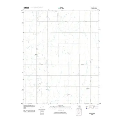
2010 Map of Peckham
USGS Topo · Published 2010About this map
The northern Oklahoma energy landscape defines this 2010 survey, where the oil and gas industry is deeply integrated into the rural grid. Major production areas like the Dilworth Oil and Gas Field and Murphy Oil Field are situated among the agricultural sections, highlighting the long-standing extraction history of Kay County. The small settlements of Peckham, Dilworth, and Bender anchor the local road network, which is organized into a precise system of section lines like W Peckham Rd and W Bender Rd.
Find a feature on this map
25 named features on this map. Tap any name to fly to it.
Don’t see what you’re looking for? This feature index may not catch every label — zoom into the map to look around manually.
Map Details
Editions of this 2010 Peckham Map
This is the sole edition of this map. No revisions or reprints were ever made.
Other maps of this area

1890 · Wellington
USGS Topo · 1:125,000

1955 · Wichita
USGS Topo · 1:250,000

1955 · Enid
USGS Topo · 1:250,000

1958 · Enid
USGS Topo · 1:250,000

1958 · Wichita
USGS Topo · 1:250,000

1965 · Portland
USGS Topo · 1:24,000

1965 · Arkansas City
USGS Topo · 1:24,000

1965 · Geuda Springs
USGS Topo · 1:24,000

1967 · Braman
USGS Topo · 1:24,000
1968 · Newkirk
USGS Topo · 1:24,000