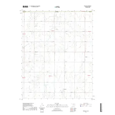
2018 Map of Peckham
USGS Topo · Published 2018About this map
The Oklahoma-Kansas state line defines the northern boundary of this landscape, where the rural settlements of Peckham and Dilworth sit amidst a grid of section-line roads. The terrain is deeply etched by a network of south-flowing drainage systems, including Spring Cr and Middle Bitter Cr in the northwest, and Lost Cr which flows past the small community of Bender. These creeks feed into the larger watershed that sustains Wentz Lake in the southern portion of the quadrangle.
Find a feature on this map
30 named features on this map. Tap any name to fly to it.
Don’t see what you’re looking for? This feature index may not catch every label — zoom into the map to look around manually.
Map Details
Editions of this 2018 Peckham Map
This is the sole edition of this map. No revisions or reprints were ever made.
Other maps of this area

1890 · Wellington
USGS Topo · 1:125,000

1955 · Wichita
USGS Topo · 1:250,000

1955 · Enid
USGS Topo · 1:250,000

1958 · Enid
USGS Topo · 1:250,000

1958 · Wichita
USGS Topo · 1:250,000

1965 · Portland
USGS Topo · 1:24,000

1965 · Arkansas City
USGS Topo · 1:24,000

1965 · Geuda Springs
USGS Topo · 1:24,000

1967 · Braman
USGS Topo · 1:24,000
1968 · Newkirk
USGS Topo · 1:24,000