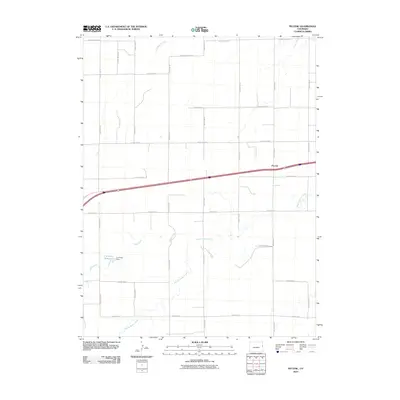
2010 Map of Peconic
USGS Topo · Published 2010About this map
Peconic sits at the center of this High Plains landscape, defined by a rigid grid of agricultural roads and the winding paths of intermittent waterways. The area is characterized by its drainage into the Middle Beaver Creek and its tributaries, including Sand Creek and Little Beaver Creek. This 2010 survey highlights the intersection of regional transportation and water management, specifically noting the C H Parks Reservoir and the C H Parks Dam in the western portion of the quadrangle. The map captures the organized layout of Kit Carson County, where numbered routes like County Rd 50 and County Rd S create a sprawling network across the prairie. The geography illustrates the essential relationship between the dry land and the vital catchments and creek beds that supported the local ranching and farming economy at the start of the 21st century.
Find a feature on this map
23 named features on this map. Tap any name to fly to it.
Don’t see what you’re looking for? This feature index may not catch every label — zoom into the map to look around manually.
Map Details
Editions of this 2010 Peconic Map
This is the sole edition of this map. No revisions or reprints were ever made.
Other maps of this area

1954 · Limon
USGS Topo · 1:250,000

1957 · Limon
USGS Topo · 1:250,000

1958 · Limon
USGS Topo · 1:250,000

1969 · Kanorado NE
USGS Topo · 1:24,000

1969 · Burlington
USGS Topo · 1:24,000

1969 · Mount Sunflower NW
USGS Topo · 1:24,000
1969 · Mount Sunflower NE
USGS Topo · 1:24,000

1969 · Peconic
USGS Topo · 1:24,000

1969 · Kanorado NW
USGS Topo · 1:24,000
1969 · Burlington NE
USGS Topo · 1:24,000