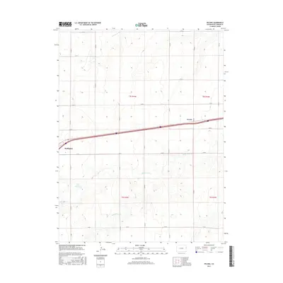
2016 Map of Peconic
USGS Topo · Published 2016About this map
Burlington and the smaller settlement of Peconic anchor the high plains of Kit Carson County in this 2016 survey. The landscape is defined by the rigid grid of the Public Land Survey System, with county roads such as Co RD 50 and Co RD X tracing section lines across the prairie. This geometry reflects the agricultural heritage of the region, where land was methodically partitioned into townships like t8s r43w and t9s r42w. Intersecting this grid is the drainage network of Middle Beaver Cr, Little Beaver Cr, and Sand Cr, which provides the only natural variation in the terrain. The presence of C H Parks Reservoir highlights the importance of water management in this semi-arid environment, serving as a vital resource for local ranching and farming operations.
Find a feature on this map
25 named features on this map. Tap any name to fly to it.
Don’t see what you’re looking for? This feature index may not catch every label — zoom into the map to look around manually.
Map Details
Editions of this 2016 Peconic Map
This is the sole edition of this map. No revisions or reprints were ever made.
Other maps of this area

1954 · Limon
USGS Topo · 1:250,000

1957 · Limon
USGS Topo · 1:250,000

1958 · Limon
USGS Topo · 1:250,000

1969 · Kanorado NE
USGS Topo · 1:24,000

1969 · Burlington
USGS Topo · 1:24,000

1969 · Mount Sunflower NW
USGS Topo · 1:24,000
1969 · Mount Sunflower NE
USGS Topo · 1:24,000

1969 · Peconic
USGS Topo · 1:24,000

1969 · Kanorado NW
USGS Topo · 1:24,000
1969 · Burlington NE
USGS Topo · 1:24,000