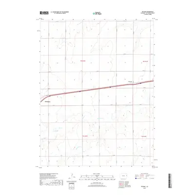
2019 Map of Peconic
USGS Topo · Published 2019About this map
Burlington marks the southwestern extent of this survey, where the regional road network converges on the High Plains of Kit Carson County. The landscape is defined by the intermittent drainages of Little Beaver Cr, Middle Beaver Cr, and Sand Cr, which carve shallow paths through the agricultural sections. A notable water management feature, the C H Park Reservoir, sits in the southwestern quadrant, illustrating the importance of surface water storage in this arid environment. The small settlement of Peconic is situated along the main east-west transportation artery, which cuts across the center of the map. The underlying cadastral survey, visible through townships such as t8s r43w and t9s r42w, shows a rigid grid of county roads, including Co RD Aa and Co RD 50, that facilitates movement between isolated farmsteads and the larger trade centers of the county.
Find a feature on this map
26 named features on this map. Tap any name to fly to it.
Don’t see what you’re looking for? This feature index may not catch every label — zoom into the map to look around manually.
Map Details
Editions of this 2019 Peconic Map
This is the sole edition of this map. No revisions or reprints were ever made.
Other maps of this area

1954 · Limon
USGS Topo · 1:250,000

1957 · Limon
USGS Topo · 1:250,000

1958 · Limon
USGS Topo · 1:250,000

1969 · Kanorado NE
USGS Topo · 1:24,000

1969 · Burlington
USGS Topo · 1:24,000

1969 · Mount Sunflower NW
USGS Topo · 1:24,000
1969 · Mount Sunflower NE
USGS Topo · 1:24,000

1969 · Peconic
USGS Topo · 1:24,000

1969 · Kanorado NW
USGS Topo · 1:24,000
1969 · Burlington NE
USGS Topo · 1:24,000