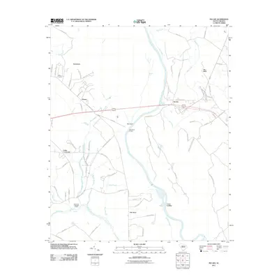
2011 Map of Pee Dee
USGS Topo · Published 2011About this map
The Great Pee Dee River winds through this coastal plain landscape, creating a series of intricate waterways and wetlands such as Muddy Gut, Bachelor Creek, and Tobys Creek. The settlement pattern in 2011 shows a mix of established rural communities and family-named landmarks, with Jamestown, Winona, and Mars Bluff serving as key points of orientation. Local history and genealogy are anchored by features like the Moody Cemetery and the notable Mars Bluff Bridge which crosses the river. The area is characterized by a network of secondary roads, including E National Cemetery Rd and Paper Mill Rd, reflecting the region's infrastructure. Small hamlets like Blue Brick and Oak Grove are situated near the river's path, while the oddly named Pepsi Cola Lake Dam D-3562 stands out as a distinct modern landmark among the traditional South Carolina lowcountry features.
Find a feature on this map
75 named features on this map. Tap any name to fly to it.
Don’t see what you’re looking for? This feature index may not catch every label — zoom into the map to look around manually.
Map Details
Editions of this 2011 Pee Dee Map
This is the sole edition of this map. No revisions or reprints were ever made.
Other maps of this area

1940 · Florence East
USGS Topo · 1:62,500

1943 · Gum Swamp
USGS Topo · 1:62,500

1945 · Florence East
USGS Topo · 1:62,500

1947 · Friendship
USGS Topo · 1:24,000

1947 · Marion
USGS Topo · 1:24,000

1953 · Florence
USGS Topo · 1:250,000

1954 · Florence
USGS Topo · 1:250,000

1960 · Latta
USGS Topo · 1:24,000
1972 · Oak Grove
USGS Topo · 1:24,000
1972 · Witherspoon Island
USGS Topo · 1:24,000