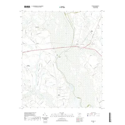
2020 Map of Pee Dee
USGS Topo · Published 2020About this map
The Great Pee Dee River serves as the central artery of this South Carolina landscape, carving through a expansive swamp system that defines the local geography. Settlements like Mars Bluff and Jamestown are positioned on the higher ground bordering the Great Pee Dee River Swamp, connected by historical routes such as the E Old Marion Hwy and E National Cemetery Rd. The map illustrates the transition from the dense wetlands of Agnay Swamp and Pitch Pot Swamp to the upland agricultural and residential pockets of Winona and Oak Grove.
Find a feature on this map
81 named features on this map. Tap any name to fly to it.
Don’t see what you’re looking for? This feature index may not catch every label — zoom into the map to look around manually.
Map Details
Editions of this 2020 Pee Dee Map
This is the sole edition of this map. No revisions or reprints were ever made.
Other maps of this area

1940 · Florence East
USGS Topo · 1:62,500

1943 · Gum Swamp
USGS Topo · 1:62,500

1945 · Florence East
USGS Topo · 1:62,500

1947 · Friendship
USGS Topo · 1:24,000

1947 · Marion
USGS Topo · 1:24,000

1953 · Florence
USGS Topo · 1:250,000

1954 · Florence
USGS Topo · 1:250,000

1960 · Latta
USGS Topo · 1:24,000
1972 · Oak Grove
USGS Topo · 1:24,000
1972 · Witherspoon Island
USGS Topo · 1:24,000