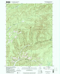
1997 Map of Peekamoose Mtn
USGS Topo · Published 2001About this map
Catskill State Park dominates this terrain, characterized by the convergence of the West Branch Neversink River and the East Branch Neversink River near Denning. The landscape is defined by its dramatic elevations, including the high peaks of Peekamoose Mtn, Table Mtn, and Slide Mtn. Small hamlets like Sundown and Greenville are situated along the lower valleys of Rondout Creek and the Vernoy Kill, demonstrating the historic pattern of settling near permanent water sources and manageable road access. The presence of several state forest preserves, such as Denning State Forest Preserve and Neversink State Forest Preserve, highlights the long-standing commitment to wilderness protection in this region. Local landmarks like Peekamoose Lake and the Buttermilk Falls Brook offer specific points of interest for those tracing the geographic history of these protected lands.
Find a feature on this map
44 named features on this map. Tap any name to fly to it.
Don’t see what you’re looking for? This feature index may not catch every label — zoom into the map to look around manually.
Map Details
Editions of this 1997 Peekamoose Mtn Map
This is the sole edition of this map. No revisions or reprints were ever made.
Other maps of this area

1900 · Phoenicia
USGS Topo · 1:62,500

1901 · Margaretville
USGS Topo · 1:62,500

1903 · Phoenicia
USGS Topo · 1:62,500

1903 · Slide Mountain
USGS Topo · 1:62,500

1904 · Margaretville
USGS Topo · 1:62,500

1905 · Slide Mountain
USGS Topo · 1:62,500

1910 · Neversink
USGS Topo · 1:62,500

1942 · West Shokan
USGS Topo · 1:24,000

1942 · Neversink
USGS Topo · 1:62,500

1942 · Lackawack
USGS Topo · 1:24,000