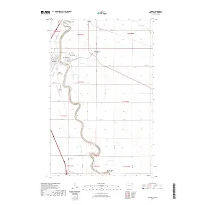
2020 Map of Pembina
USGS Topo · Published 2020About this map
The Red River Valley of the North serves as the winding interstate border between North Dakota and Minnesota, defining the settlement patterns of this 2020 survey. At the international boundary, the border town of Noyes sits adjacent to the meandering river, while just south, the historic rail and road infrastructure converges at St. Vincent and Saint Vincent Junction. Across the water in North Dakota, the city of Pembina is laid out on a grid including Pacific Ave and Atlantic Ave, positioned where the Pembina River joins the larger Red River system.
Find a feature on this map
50 named features on this map. Tap any name to fly to it.
Don’t see what you’re looking for? This feature index may not catch every label — zoom into the map to look around manually.
Map Details
Editions of this 2020 Pembina Map
This is the sole edition of this map. No revisions or reprints were ever made.
Other maps of this area

1939 · Pembina
USGS Topo · 1:62,500

1941 · Bathgate
USGS Topo · 1:62,500

1941 · Pembina
USGS Topo · 1:62,500

1952 · Thief River Falls
USGS Topo · 1:250,000

1956 · Thief River Falls
USGS Topo · 1:250,000

1957 · Thief River Falls
USGS Topo · 1:250,000

1967 · Thief River Falls
USGS Topo · 1:250,000
1970 · Bathgate SE
USGS Topo · 1:24,000
1970 · Bathgate NE
USGS Topo · 1:24,000
1972 · Joliette
USGS Topo · 1:24,000