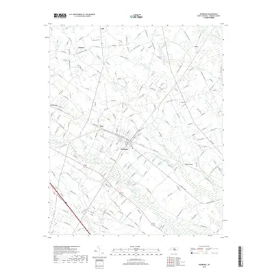
2019 Map of Pembroke
USGS Topo · Published 2019About this map
The town of Pembroke serves as the central hub of this Robeson County landscape, where the intersection of major roads and rail lines historically shaped the local economy. The geography is defined by an intricate network of wetlands and drainage systems, including Moss Neck Swamp and the meandering Lumber River to the south. Surrounding settlements like Pates, Prospect, and Moss Neck are connected by a grid of rural routes such as Prospect Rd and Deep Branch Rd, reflecting a pattern of agricultural development and dispersed residential communities. Local hydrology is particularly prominent, with numerous named branches and swamps like Watering Hole Swamp and Bear Swamp punctuating the low-lying terrain. These water features dictated the placement of early crossings and the layout of the region's farms and timberlands throughout the late twentieth century.
Find a feature on this map
195 named features on this map. Tap any name to fly to it.
Don’t see what you’re looking for? This feature index may not catch every label — zoom into the map to look around manually.
Map Details
Editions of this 2019 Pembroke Map
This is the sole edition of this map. No revisions or reprints were ever made.
Other maps of this area

1949 · Wakulla
USGS Topo · 1:24,000

1949 · Laurinburg
USGS Topo · 1:62,500

1953 · Florence
USGS Topo · 1:250,000

1954 · Florence
USGS Topo · 1:250,000

1972 · Northwest Lumberton
USGS Topo · 1:24,000

1972 · Southwest Lumberton
USGS Topo · 1:24,000

1972 · Rennert
USGS Topo · 1:24,000

1972 · Pembroke
USGS Topo · 1:24,000
1972 · Rowland
USGS Topo · 1:24,000
1972 · Mc Donald
USGS Topo · 1:24,000