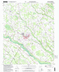
2002 Map of Pembroke
USGS Topo · Published 2002About this map
The Pembroke State Univ campus anchors this 2002 topographic study, illustrating the educational heart of Pembroke. Situated along the southern reach of the Lumber River, the landscape is defined by an intricate network of wetlands, including Watering Hole Swamp, Bear Swamp, and Juniper Swamp. These lowlands are interspersed with evidence of local industry, specifically several Sandpits near the riverbanks.
Find a feature on this map
60 named features on this map. Tap any name to fly to it.
Don’t see what you’re looking for? This feature index may not catch every label — zoom into the map to look around manually.
Map Details
Editions of this 2002 Pembroke Map
This is the sole edition of this map. No revisions or reprints were ever made.
Other maps of this area

1949 · Wakulla
USGS Topo · 1:24,000

1949 · Laurinburg
USGS Topo · 1:62,500

1953 · Florence
USGS Topo · 1:250,000

1954 · Florence
USGS Topo · 1:250,000

1972 · Northwest Lumberton
USGS Topo · 1:24,000

1972 · Southwest Lumberton
USGS Topo · 1:24,000

1972 · Rennert
USGS Topo · 1:24,000

1972 · Pembroke
USGS Topo · 1:24,000
1972 · Rowland
USGS Topo · 1:24,000
1972 · Mc Donald
USGS Topo · 1:24,000