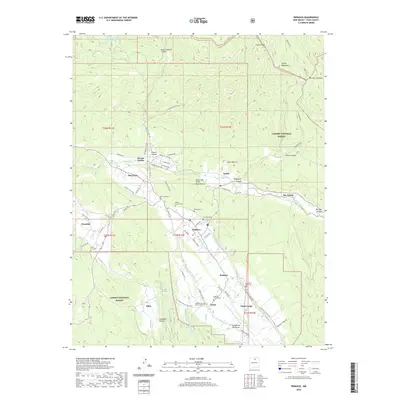
2020 Map of Penasco
USGS Topo · Published 2020About this map
Picuris Pueblo and the surrounding high-altitude villages of Taos County anchor this landscape, where traditional water management remains central to the community. The complex network of irrigation ditches, including the Acequia Madre and Chamisal Ditch, illustrates a long-standing agricultural heritage that follows the courses of Rio Pueblo and Rio Santa Barbara. These waterways descend from the Picuris Mountains and Sangre de Cristo Mountains, sustaining settlements like Peñasco and Rodarte along the valley floor. Genealogy researchers will find significant detail in the numerous community burial grounds, such as the San Pedro Cem and Ramon Sanchez Cem. The presence of the Carson National Forest and historic routes like the Camino Real reflect the area's transition from an ancient crossroads to a contemporary rural center.
Find a feature on this map
84 named features on this map. Tap any name to fly to it.
Don’t see what you’re looking for? This feature index may not catch every label — zoom into the map to look around manually.
Map Details
Editions of this 2020 Penasco Map
This is the sole edition of this map. No revisions or reprints were ever made.
Other maps of this area

1953 · Truchas
USGS Topo · 1:24,000

1953 · Trampas
USGS Topo · 1:24,000

1954 · Raton
USGS Topo · 1:250,000

1958 · Raton
USGS Topo · 1:250,000

1961 · Carson
USGS Topo · 1:24,000

1964 · Tres Ritos
USGS Topo · 1:24,000

1964 · Ranchos De Taos
USGS Topo · 1:24,000

1964 · Penasco
USGS Topo · 1:24,000

1964 · Taos SW
USGS Topo · 1:24,000
1964 · Jicarita Peak
USGS Topo · 1:24,000