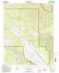
1995 Map of Penasco
USGS Topo · Published 1997About this map
The high mountain valley of the Picuris Mountains is defined by ancient land grants and a sophisticated network of traditional irrigation canals known as acequias. These gravity-fed channels, including the Acequia Madre de Santa Barbara and Acequia del Llano, wind through the landscape to support the historic communities of Peñasco, Rodarte, and Llano. The map clearly delineates the complex boundaries between the Carson National Forest and several Spanish and Pueblo land grants, such as the Picuris Pueblo Grant and the Llano Santa Barbara Grant. Cultural heritage is central to this area, where Picuris Pueblo sits near the confluence of Rio Pueblo and Embudo Creek. Transportation and communication markers like the Camino Real and a Telephone Trail cut through the high-altitude terrain, connecting remote settlements with the larger region.
Find a feature on this map
56 named features on this map. Tap any name to fly to it.
Don’t see what you’re looking for? This feature index may not catch every label — zoom into the map to look around manually.
Map Details
Editions of this 1995 Penasco Map
This is the sole edition of this map. No revisions or reprints were ever made.
Other maps of this area

1953 · Truchas
USGS Topo · 1:24,000

1953 · Trampas
USGS Topo · 1:24,000

1954 · Raton
USGS Topo · 1:250,000

1958 · Raton
USGS Topo · 1:250,000

1961 · Carson
USGS Topo · 1:24,000

1964 · Tres Ritos
USGS Topo · 1:24,000

1964 · Ranchos De Taos
USGS Topo · 1:24,000

1964 · Penasco
USGS Topo · 1:24,000

1964 · Taos SW
USGS Topo · 1:24,000
1964 · Jicarita Peak
USGS Topo · 1:24,000