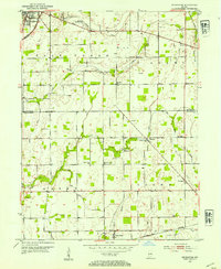
1953 Map of Pendleton
USGS Topo · Published 1954About this map
Pendleton serves as the primary hub in this mid-century survey, situated at the intersection of the New York Central railroad and Central Ave. The landscape transitions from this concentrated settlement into the agricultural townships of Fall Creek, Adams, Green, and Brown. A network of drainage ditches, including Manifold Ditch, Dunwoody DITCH, and Pee Dee Ditch, highlights the extensive reclamation of the fertile till plains for farming, a defining characteristic of this part of the Indiana corn belt.
Find a feature on this map
36 named features on this map. Tap any name to fly to it.
Don’t see what you’re looking for? This feature index may not catch every label — zoom into the map to look around manually.
Map Details
Editions of this 1953 Pendleton Map
2 editions found
Other maps of this area

1952 · Greenfield
USGS Topo · 1:24,000

1952 · Ingalls
USGS Topo · 1:24,000

1952 · Anderson
USGS Topo · 1:24,000

1953 · Pendleton
USGS Topo · 1:24,000

1953 · Lapel
USGS Topo · 1:24,000

1953 · Cincinnati
USGS Topo · 1:250,000

1953 · Muncie
USGS Topo · 1:250,000

1956 · Muncie
USGS Topo · 1:250,000

1956 · Cleveland
USGS Topo · 1:24,000

1957 · Cincinnati
USGS Topo · 1:250,000