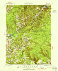
1929 Map of Penfield
USGS Topo · Published 1954About this map
The Bennett Branch Susquehanna River and Anderson Creek drain this section of the Allegheny Plateau as it appeared in the late 1920s. Centered on the rugged divide of Boone Mountain, the landscape is defined by its industrial and conservation infrastructure, featuring the Clearfield Nursery and several remote outposts like Smith Fire Tower and Gordon Camp. The western edge shows the expansion of Du Bois and Oklahoma, while the interior remains a network of high-elevation townships including Huston and Union.
Find a feature on this map
119 named features on this map. Tap any name to fly to it.
Don’t see what you’re looking for? This feature index may not catch every label — zoom into the map to look around manually.
Map Details
Editions of this 1929 Penfield Map
3 editions found
Other maps of this area

1903 · Curwensville
USGS Topo · 1:62,500

1903 · Houtzdale
USGS Topo · 1:62,500

1905 · Houtzdale
USGS Topo · 1:62,500

1906 · Punxsutawney
USGS Topo · 1:62,500

1922 · Du Bois
USGS Topo · 1:62,500

1924 · Du Bois
USGS Topo · 1:62,500

1929 · Clearfield
USGS Topo · 1:48,000

1929 · Penfield
USGS Topo · 1:62,500

1932 · Clearfield
USGS Topo · 1:62,500

1932 · Penfield
USGS Topo · 1:62,500