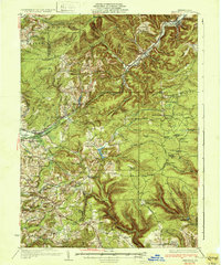
1932 Map of Penfield
USGS Topo · Published 1932About this map
The Bennett Branch Susquehanna River valley defines the northeastern portion of this 1932 Pennsylvania survey, where the Pennsylvania RR and Pennsylvania State Highway follow the waterway through Penfield and Winterburn. To the southwest, the Buffalo Rochester and Pittsburgh RR cuts across the divide near Sabula, signaling the region's importance as a transit corridor for natural resources. This landscape is a patchwork of small upland settlements and early conservation efforts, evidenced by the Clearfield Nursery and various public camps. Local life in the early 1930s is visible through the dense network of one-room schoolhouses like Pine Grove Sch and Hickory Hill Sch, alongside religious landmarks such as the Reformed Ch. High points like Boone Mountain and the Smith Fire Tower provide surveillance over the recovering timberlands, while the Airplane Landing Field near Du Bois marks the arrival of aviation to this rural sector.
Find a feature on this map
87 named features on this map. Tap any name to fly to it.
Don’t see what you’re looking for? This feature index may not catch every label — zoom into the map to look around manually.
Map Details
Editions of this 1932 Penfield Map
3 editions found
Other maps of this area

1903 · Curwensville
USGS Topo · 1:62,500

1903 · Houtzdale
USGS Topo · 1:62,500

1905 · Houtzdale
USGS Topo · 1:62,500

1906 · Punxsutawney
USGS Topo · 1:62,500

1922 · Du Bois
USGS Topo · 1:62,500

1924 · Du Bois
USGS Topo · 1:62,500

1929 · Clearfield
USGS Topo · 1:48,000

1929 · Penfield
USGS Topo · 1:62,500

1932 · Clearfield
USGS Topo · 1:62,500

1932 · Penfield
USGS Topo · 1:62,500