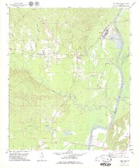
1978 Map of Pennington
USGS Topo · Published 1979About this map
The Tombigbee River forms the eastern boundary of this West Alabama landscape, defining the border between Choctaw and Marengo counties. In the late 1970s, the region was characterized by the intersection of river-based infrastructure and timber or industrial interests, evidenced by the Meridian and Bigbee Railroad corridor and the Industrial Waste Ponds near Naheola. The town of Pennington serves as a central hub, surrounded by several smaller settlements and local landmarks that reflect the area's rural social fabric. Significant community sites such as Trinity Ch, Ebenezer Ch, and Little Zion Ch are noted alongside the Millwood Cem. To the south, the terrain transitions toward the waters of Coffeeville Lake, where a Fish Hatchery and Compton Landing suggest the importance of the river for both local economy and recreation. The mapping of multiple sandpits along the Tuckabum Creek drainage points to active local extraction during this era.
Find a feature on this map
45 named features on this map. Tap any name to fly to it.
Don’t see what you’re looking for? This feature index may not catch every label — zoom into the map to look around manually.
Map Details
Editions of this 1978 Pennington Map
This is the sole edition of this map. No revisions or reprints were ever made.
Other maps of this area

1953 · Montgomery
USGS Topo · 1:250,000

1953 · Meridian
USGS Topo · 1:250,000

1956 · Montgomery
USGS Topo · 1:250,000

1957 · Meridian
USGS Topo · 1:250,000

1957 · Montgomery
USGS Topo · 1:250,000

1965 · Meridian
USGS Topo · 1:250,000

1970 · Myrtlewood North
USGS Topo · 1:24,000

1971 · Whitfield
USGS Topo · 1:24,000

1971 · Gaston
USGS Topo · 1:24,000
1978 · Putnam
USGS Topo · 1:24,000