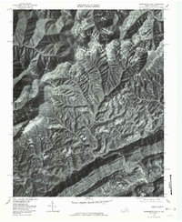
1976 Map of Pennington Gap
USGS Topo · Published 1981About this map
The North Fork Powell River carves through the landscape of Lee County during the mid-1970s, anchoring the primary settlement of Pennington Gap. This orthophotoquad, produced from aerial photography by the Commonwealth of Virginia Division of Mineral Resources, reveals the intricate relationship between the mountainous topography and the corridor of human activity that follows the valley floor. Steep ridgelines separate narrow hollows where communities like Bonny Blue and St Charles developed, largely defined by the drainage patterns of Straight Creek and Stone Creek. The map provides an overhead view of the region's industrial and residential footprint, showing the density of structures along the valley floors near Dizney and the crossing waters of the Clover Fk Cumberland River. The visual data highlights the sharp contrast between the densely forested slopes and the cleared land concentrated along the riverbanks and creeks.
Find a feature on this map
11 named features on this map. Tap any name to fly to it.
Don’t see what you’re looking for? This feature index may not catch every label — zoom into the map to look around manually.
Map Details
Editions of this 1976 Pennington Gap Map
This is the sole edition of this map. No revisions or reprints were ever made.
Other maps of this area

1887 · Jonesville
USGS Topo · 1:125,000

1891 · Jonesville
USGS Topo · 1:125,000

1894 · Estillville
USGS Topo · 1:125,000

1916 · Nolansburg
USGS Topo · 1:48,000

1919 · Nolansburg
USGS Topo · 1:62,500

1921 · Big Stone Gap
USGS Topo · 1:48,000

1922 · Big Stone Gap
USGS Topo · 1:62,500

1929 · Big Stone Gap
USGS Topo · 1:62,500

1935 · Hubbard Springs
USGS Topo · 1:24,000
1935 · Evarts
USGS Topo · 1:24,000