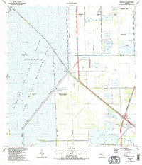
1988 Map of Pennsuco
USGS Topo · Published 1988About this map
The Everglades State Wildlife Management Area dominates the western half of this 1980s landscape, illustrating the engineered border between Florida’s preserved wetlands and its expanding suburban fringe. This boundary is sharply defined by the Snake Creek Canal No C-9 and various embankments like Levee No 67-C. To the east, the map captures the industrial and infrastructure development characteristic of the era, where numerous quarries dot the terrain near the Homestead Extension of the turnpike. The small settlement of Pennsuco sits at the junction of the Pennsuco Canal and the highway, while the presence of the Opa-Locka West Airport and several radio facilities indicates the region's role as a logistical hub. Significant recreational and conservation spaces, such as Milton E. Thompson County Park and Draft Dodge Island, provide a buffer between the managed wilderness and the growing communities of Miramar and Pembroke Pines.
Find a feature on this map
28 named features on this map. Tap any name to fly to it.
Don’t see what you’re looking for? This feature index may not catch every label — zoom into the map to look around manually.
Map Details
Editions of this 1988 Pennsuco Map
2 editions found
Other maps of this area

1949 · Opalocka
USGS Topo · 1:24,000

1950 · Hialeah
USGS Topo · 1:24,000

1956 · Miami
USGS Topo · 1:250,000

1956 · West Palm Beach
USGS Topo · 1:250,000

1957 · West Palm Beach
USGS Topo · 1:250,000

1958 · West Palm Beach
USGS Topo · 1:250,000

1958 · Miami
USGS Topo · 1:250,000
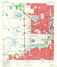
1962 · Hialeah
USGS Topo · 1:24,000

1962 · Opa-locka
USGS Topo · 1:24,000

1963 · Pennsuco
USGS Topo · 1:24,000