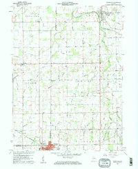
1960 Map of Pennville
USGS Topo · Published 1961About this map
Pennville serves as the focal point of this 1960 Indiana survey, situated where the Salamonie River flows through the northeast. This landscape is a dense network of agricultural drainages and small creeks, including Brooks Creek and Crooked Creek, which have shaped the settlement patterns of Jay, Blackford, and Delaware Counties. The southern portion of the map highlights the industrial and transport corridor at Dunkirk, where the Pennsylvania railroad line cuts through the terrain near the Sewage Disp and Substation.
Find a feature on this map
76 named features on this map. Tap any name to fly to it.
Don’t see what you’re looking for? This feature index may not catch every label — zoom into the map to look around manually.
Map Details
Editions of this 1960 Pennville Map
2 editions found
Other maps of this area

1953 · Muncie
USGS Topo · 1:250,000

1956 · Muncie
USGS Topo · 1:250,000

1960 · Pennville
USGS Topo · 1:24,000

1960 · Hartford City East
USGS Topo · 1:24,000

1960 · Blaine
USGS Topo · 1:24,000

1960 · Eaton
USGS Topo · 1:24,000

1960 · Ridgeville
USGS Topo · 1:24,000
1960 · Redkey
USGS Topo · 1:24,000

1962 · Montpelier
USGS Topo · 1:24,000

1962 · Petroleum
USGS Topo · 1:24,000