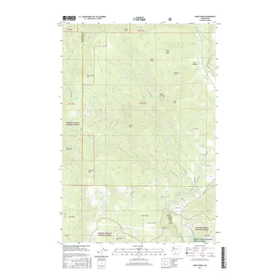
2017 Map of Penny Ridge
USGS Topo · Published 2017About this map
The White Salmon River cuts through this high-elevation landscape on the border of Skamania and Klickitat counties, where the Gifford Pinchot National Forest dominates the terrain. Centered on the settlement of B Z Corner, the area is defined by a series of prominent peaks and ridgelines, including Penny Ridge, Nestor Peak, and the Monte Cristo Range. A complex network of drainage systems, such as Buck Creek and Mill Cr, flows through deep-cut features like McIlroy Canyon. To the south, the Spring Creek National Fish Hatchery sits near the base of Underwood Mtn. This 2017 survey illustrates the intersection of conservation and utility, mapping out numerous forest roads like Buck Creek Rd and Little Buck Creek Rd that provide access to the timberlands and remote landmarks such as Cedar Swamp and Whistling Ridge.
Find a feature on this map
55 named features on this map. Tap any name to fly to it.
Don’t see what you’re looking for? This feature index may not catch every label — zoom into the map to look around manually.
Map Details
Editions of this 2017 Penny Ridge Map
This is the sole edition of this map. No revisions or reprints were ever made.
Other maps of this area

1926 · Hood River
USGS Topo · 1:125,000

1929 · Hood River
USGS Topo · 1:125,000

1934 · The Dalles
USGS Topo · 1:125,000

1953 · The Dalles
USGS Topo · 1:250,000

1956 · The Dalles
USGS Topo · 1:250,000

1957 · The Dalles
USGS Topo · 1:250,000

1957 · Willard
USGS Topo · 1:62,500

1957 · White Salmon
USGS Topo · 1:62,500

1957 · Husum
USGS Topo · 1:62,500

1957 · Hood River
USGS Topo · 1:62,500