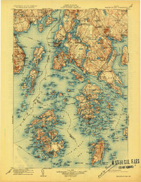
1905 Map of Penobscot Bay
USGS Topo · Published 1927About this map
Penobscot Bay serves as the focal point of this coastal survey, where the intricate geography of Maine's mid-coast region is documented at the opening of the twentieth century. The map details a complex maritime landscape defined by major landmasses like Deer Isle and Vinalhaven Island, alongside dozens of smaller features such as Seven Hundred Acre Island and Sears Island. Early twentieth-century settlements like Stockton Springs, Castine, and Belfast appear as established coastal hubs, connected by steamboat routes that navigate through Eggemoggin Reach and Hurricane Sound.
Find a feature on this map
62 named features on this map. Tap any name to fly to it.
Don’t see what you’re looking for? This feature index may not catch every label — zoom into the map to look around manually.
Map Details
Editions of this 1905 Penobscot Bay Map
3 editions found

Other maps of this area

1900 · Orland
USGS Topo · 1:62,500

1900 · Bucksport
USGS Topo · 1:62,500

1902 · Bucksport
USGS Topo · 1:62,500

1902 · Castine
USGS Topo · 1:62,500

1904 · Deer Isle
USGS Topo · 1:62,500

1904 · Castine
USGS Topo · 1:62,500

1904 · Mount Desert
USGS Topo · 1:62,500

1904 · Swan Island
USGS Topo · 1:62,500

1904 · Bluehill
USGS Topo · 1:62,500

1904 · Vinalhaven
USGS Topo · 1:62,500