
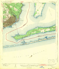
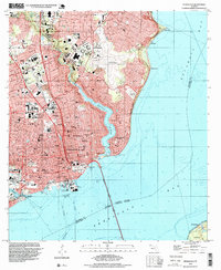
1941 Map of Pensacola
USGS Topo · Published 1956About this map
The dense urban core of Pensacola and its sprawling waterfront dominate this early 1940s survey. The city's maritime and industrial foundations are clearly visible at Muscogee Wharf and along the Louisville and Nashville railroad lines that feed into the harbor. Beyond the city grid, the landscape transitions into established neighborhoods like East Pensacola Heights and northern settlements such as Goulding and Brent.
Find a feature on this map
56 named features on this map. Tap any name to fly to it.
Don’t see what you’re looking for? This feature index may not catch every label — zoom into the map to look around manually.
Map Details
Editions of this 1941 Pensacola Map
This is the sole edition of this map. No revisions or reprints were ever made.
Historical Maps of 9th Avenue Apartments Through Time
11 maps found

1921 Pensacola
Escambia County, FL
1941 Pensacola
Escambia County, FL
1942 Pensacola
Escambia County, FL

1944 Pensacola
Escambia County, FL
1957 Pensacola
Escambia County, FL

1959 Pensacola
Escambia County, FL

1960 Pensacola
Escambia County, FL
1970 Pensacola
Escambia County, FL
1978 Pensacola
Escambia County, FL
1994 Pensacola
Escambia County, FL
2024 Pensacola
Escambia County, FL