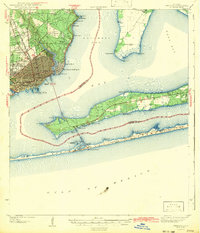
1942 Map of Pensacola
USGS Topo · Published 1942About this map
Pensacola stands at the center of this coastal landscape just as the United States entered the Second World War. The city's waterfront is defined by industrial activity at the Muscogee Wharf and the Louisville and Nashville railroad line, while the surrounding communities of Goulding and Brent show a mix of early suburban growth and wooded tracts. To the north and east, small settlements like Oakland and Bohemia dot the shores of Escambia Bay, many centered around local institutions like Oakland Ch.
Find a feature on this map
53 named features on this map. Tap any name to fly to it.
Don’t see what you’re looking for? This feature index may not catch every label — zoom into the map to look around manually.
Map Details
Editions of this 1942 Pensacola Map
2 editions found

Other maps of this area

1920 · Milton
USGS Topo · 1:62,500

1921 · Holley
USGS Topo · 1:62,500

1921 · Pensacola
USGS Topo · 1:62,500

1921 · Fort Barrancas
USGS Topo · 1:62,500

1921 · Muscogee
USGS Topo · 1:62,500

1934 · Harold
USGS Topo · 1:62,500

1936 · Holley
USGS Topo · 1:48,000

1937 · Harold
USGS Topo · 1:62,500

1938 · Holley
USGS Topo · 1:62,500

1938 · Harold
USGS Topo · 1:62,500