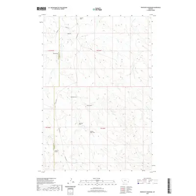
2020 Map of Pentecost Reservoir
USGS Topo · Published 2020About this map
Pentecost Reservoir sits at the southern edge of this landscape, serving as a vital water source in a region defined by its complex drainage network. The terrain is deeply incised by numerous seasonal watercourses, including Pentecost Draw, Quaking Aspen Draw, and Reynolds Draw. These draws and canyons, such as Cedar Canyon and Kuster Canyon, illustrate the erosive forces at work across the high plains of the Powder River and Carter county line.
Find a feature on this map
24 named features on this map. Tap any name to fly to it.
Don’t see what you’re looking for? This feature index may not catch every label — zoom into the map to look around manually.
Map Details
Editions of this 2020 Pentecost Reservoir Map
This is the sole edition of this map. No revisions or reprints were ever made.
Other maps of this area

1954 · Ekalaka
USGS Topo · 1:250,000

1956 · Ekalaka
USGS Topo · 1:250,000

1958 · Ekalaka
USGS Topo · 1:250,000

1965 · Ekalaka
USGS Topo · 1:250,000

1979 · W L Butte
USGS Topo · 1:24,000

1979 · McKenzie Creek
USGS Topo · 1:24,000
1979 · Pocochichee Butte
USGS Topo · 1:24,000

1980 · Broadus
USGS Topo · 1:100,000

1981 · Alzada
USGS Topo · 1:100,000

1982 · Phillippi Reservoir
USGS Topo · 1:24,000