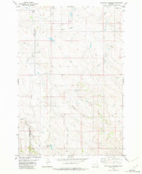
1982 Map of Pentecost Reservoir
USGS Topo · Published 1982About this map
Haystack Butte and the winding drainages of the Powder River Co Carter Co line dominate this 1982 topographic survey of southeastern Montana. The landscape is defined by an intricate network of intermittent waterways, including the three-pronged system of Dry Creek, North Fork Dry Creek, and South Fork Dry Creek. Human infrastructure is sparse, characterized by a few Landing Strips and several Drill Hole markers scattered among the draws. The namesake Pentecost Reservoir and its associated Pentecost Draw serve as focal points in the southern portion of the map, illustrating the essential role of water management in this arid ranching country. From Reynolds Draw to the deeply etched Kuster Canyon, the topography reveals a highly eroded terrain where every named feature relates to the flow of water or the distinctive rise of buttes.
Find a feature on this map
18 named features on this map. Tap any name to fly to it.
Don’t see what you’re looking for? This feature index may not catch every label — zoom into the map to look around manually.
Map Details
Editions of this 1982 Pentecost Reservoir Map
This is the sole edition of this map. No revisions or reprints were ever made.
Other maps of this area

1954 · Ekalaka
USGS Topo · 1:250,000

1956 · Ekalaka
USGS Topo · 1:250,000

1958 · Ekalaka
USGS Topo · 1:250,000

1965 · Ekalaka
USGS Topo · 1:250,000

1979 · W L Butte
USGS Topo · 1:24,000

1979 · McKenzie Creek
USGS Topo · 1:24,000
1979 · Pocochichee Butte
USGS Topo · 1:24,000

1980 · Broadus
USGS Topo · 1:100,000

1981 · Alzada
USGS Topo · 1:100,000

1982 · Phillippi Reservoir
USGS Topo · 1:24,000