
1947 Map of Penuelas NE
USGS Topo · Published 1947About this map
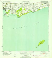
Río Portugués cuts a deep path through the interior highlands north of Ponce in this 1943 topography, revealing a landscape defined by sharp elevation changes and agricultural settlement. The map documents the rural character of Barrio Margueño, where the small cluster at Marueño and the larger settlement of Corral Viejo served as local hubs. Of particular note for local history is the Escuela Segunda Unidad de Corral Viejo, a vocational school type common in mid-century rural Puerto Rico. To the northeast, the estate at Hacienda Burenes indicates the long-standing importance of landholding patterns in the valley. Dominated by the heights of Cerro del Diablo, the terrain transitions across the administrative boundary between the Municipio de Peñuelas and Municipio de Ponce.
Find a feature on this map
8 named features on this map. Tap any name to fly to it.
Don’t see what you’re looking for? This feature index may not catch every label — zoom into the map to look around manually.
Map Details
Editions of this 1947 Penuelas NE Map
This is the sole edition of this map. No revisions or reprints were ever made.
Historical Maps of Monte Llano Through Time
19 maps found

1945 Playa De Ponce
Ponce Municipio, PR

1946 Punta Cuchara
Ponce Municipio, PR

1947 Adjuntas SE
Ponce Municipio, PR

1947 Jayuya SO
Ponce Municipio, PR
1947 Penuelas NE
Ponce Municipio, PR

1947 Penuelas SE
Ponce Municipio, PR

1947 Playa De Ponce NO
Ponce Municipio, PR

1947 Ponce NO
Ponce Municipio, PR

1947 Ponce SO
Ponce Municipio, PR

1947 Punta Gughara NE
Ponce Municipio, PR
1952 Playa De Ponce
Ponce Municipio, PR

1952 Punta Cuchara
Ponce Municipio, PR

1958 Playa De Ponce
Ponce Municipio, PR

1958 Punta Cucharas
Ponce Municipio, PR

1962 Playa De Ponce
Ponce Municipio, PR
1962 Punta Cucharas
Ponce Municipio, PR
1970 Playa De Ponce
Ponce Municipio, PR

2024 Playa De Ponce
Ponce Municipio, PR

2024 Punta Cucharas
Ponce Municipio, PR