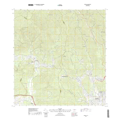
2018 Map of Penuelas
USGS Topo · Published 2018About this map
The town of Peñuelas sits as a central hub in this modern survey, marking the transition from the interior mountains toward the southern coast. This area is characterized by a dense network of watercourses, including the Río Tallaboa and Río Guayanés, which have historically shaped the settlement patterns and agricultural development of the region. The landscape is punctuated by prominent peaks such as Cerro Mata de Plátano and the Cerrote de Peñuelas, while the eastern portion of the map transitions into the urban expansion of Ponce. Genealogists and local historians will find significant value in the documentation of numerous burial sites, ranging from the Cementerio Municipal de Peñuelas to the Cementerio Civil de Ponce and the Cementerio Católico San Vicente de Paúl. These sites, alongside smaller settlements like Corral Viejo and Tallaboa, reflect the deep cultural and community roots established across the southern foothills of the Island of Puerto Rico.
Find a feature on this map
30 named features on this map. Tap any name to fly to it.
Don’t see what you’re looking for? This feature index may not catch every label — zoom into the map to look around manually.
Map Details
Editions of this 2018 Penuelas Map
This is the sole edition of this map. No revisions or reprints were ever made.
Other maps of this area

1945 · Playa De Ponce
USGS Topo · 1:30,000

1945 · Ponce
USGS Topo · 1:30,000

1946 · Punta Cuchara
USGS Topo · 1:30,000

1946 · Yauco
USGS Topo · 1:30,000

1946 · Jayuya
USGS Topo · 1:30,000

1946 · Monte Guilarte
USGS Topo · 1:30,000

1946 · Punta Verraco
USGS Topo · 1:30,000

1946 · Penuelas
USGS Topo · 1:30,000

1946 · Adjuntas
USGS Topo · 1:30,000
1947 · Yauco NE
USGS Topo · 1:10,000
Featured Places
- Peñuelas
- Sector Los Cruz, Ponce
- Sector Los Garcías, Ponce
- Sector La Gelpa, Peñuelas
- Sector Loyola, Peñuelas