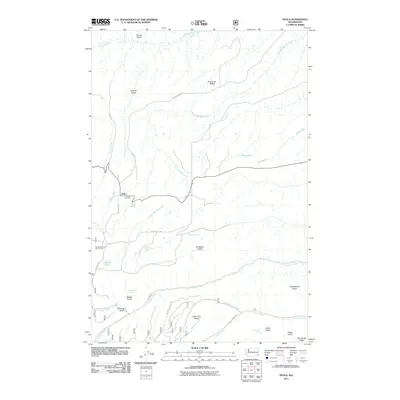
2011 Map of Peola
USGS Topo · Published 2011About this map
Peola serves as the central focal point of this high-plateau landscape in Garfield County, where the historic Pioneer Cemetery and Pataha Research Natural Area reflect a legacy of early settlement and conservation. The terrain is defined by a series of prominent ridges and deep drainages, notably Knotgrass Ridge and Cape Horn Ridge, which divide the watershed between Alpowa Creek and the long course of Pow Wah Kee Creek.
Find a feature on this map
33 named features on this map. Tap any name to fly to it.
Don’t see what you’re looking for? This feature index may not catch every label — zoom into the map to look around manually.
Map Details
Editions of this 2011 Peola Map
This is the sole edition of this map. No revisions or reprints were ever made.
Other maps of this area

1937 · Pomeroy
USGS Topo · 1:96,000

1942 · Pomeroy
USGS Topo · 1:125,000

1943 · Peola
USGS Topo · 1:62,500

1943 · Saddle Butte
USGS Topo · 1:62,500

1946 · Saddle Butte
USGS Topo · 1:62,500

1946 · Peola
USGS Topo · 1:62,500

1955 · Pullman
USGS Topo · 1:250,000

1958 · Pullman
USGS Topo · 1:250,000

1967 · Rose Springs
USGS Topo · 1:24,000
1967 · Pomeroy
USGS Topo · 1:24,000