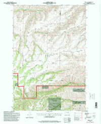
1995 Map of Peola
USGS Topo · Published 1998About this map
Peola serves as the central settlement on this mid-1990s survey, positioned near the Pioneer Cemetery and the intersection of Kimble Road and Fitzgerald Road. The landscape is defined by deep drainage systems like Robinson Gulch and Blankenship Gulch that carve through prominent heights such as Knotgrass Ridge and Pleasant Ridge. To the south, the terrain transitions into the protected acreage of the Umatilla National Forest and the Asotin Wildlife Area, where land use shifts from the agricultural plateaus of the north to more complex ridge-and-gulch topography.
Find a feature on this map
65 named features on this map. Tap any name to fly to it.
Don’t see what you’re looking for? This feature index may not catch every label — zoom into the map to look around manually.
Map Details
Editions of this 1995 Peola Map
This is the sole edition of this map. No revisions or reprints were ever made.
Other maps of this area

1937 · Pomeroy
USGS Topo · 1:96,000

1942 · Pomeroy
USGS Topo · 1:125,000

1943 · Peola
USGS Topo · 1:62,500

1943 · Saddle Butte
USGS Topo · 1:62,500

1946 · Saddle Butte
USGS Topo · 1:62,500

1946 · Peola
USGS Topo · 1:62,500

1955 · Pullman
USGS Topo · 1:250,000

1958 · Pullman
USGS Topo · 1:250,000

1967 · Rose Springs
USGS Topo · 1:24,000
1967 · Pomeroy
USGS Topo · 1:24,000