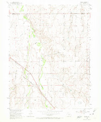
1956 Map of Peoria
USGS Topo · Published 1975About this map
Peoria serves as the primary focal point on the western edge of this High Plains landscape, situated along the vital transport artery of the Union Pacific railroad. The terrain is defined by the braided drainage patterns of East Bijou Creek and Middle Bijou Creek, which cut through the rolling country of Arapahoe and Adams counties. Evidence of mid-century infrastructure is found in the northern reaches, where a Truck Inspection Station sits near the county line, while a Pipeline and multiple Levees suggest active water and resource management. Beyond the tracks, the land is etched by numerous watercourses including Rattlesnake Creek, Lone Tree Gulch, and Cabin Gulch. This 1956 survey, compiled in part from 1950 aerial photography, captures the rural character of the region before significant suburban expansion, highlighting the sparse but critical network of rural roads and early industrial markers like the local Gravel Pit.
Find a feature on this map
16 named features on this map. Tap any name to fly to it.
Don’t see what you’re looking for? This feature index may not catch every label — zoom into the map to look around manually.
Map Details
Editions of this 1956 Peoria Map
4 editions found
Other maps of this area

1951 · Leader SE
USGS Topo · 1:24,000

1952 · Leader SW
USGS Topo · 1:24,000

1953 · Denver
USGS Topo · 1:250,000

1954 · Limon
USGS Topo · 1:250,000

1956 · Peoria
USGS Topo · 1:24,000

1956 · Byers
USGS Topo · 1:24,000

1957 · Denver
USGS Topo · 1:250,000

1957 · Limon
USGS Topo · 1:250,000

1958 · Limon
USGS Topo · 1:250,000

1958 · Denver
USGS Topo · 1:250,000