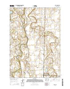
2014 Map of Peoria
USGS Topo · Published 2014About this map
Peoria sits along the eastern bank of the Willamette River, where the landscape is defined by an intricate network of waterways and mid-river islands. The boundary between Linn Co and Benton Co weaves through a series of complex river features, including Snag Boat Bend, Jacobs Bend, and Sam Daws Bend. These river bends, along with the Booneville Channel and Albany Channel, illustrate the shifting nature of the floodplain. Local family history is preserved in several small burial grounds such as Miller-Coon Cem, Pugh Cem, and Brattain Cem, which are scattered among the agricultural plots east of the river. Aviation infrastructure is visible through smaller facilities like Schrock Airport and Jim's Airstrip. The southern portion of the area is drained by the Long Tom River and Johnston Slough, highlighting the low-lying, water-dependent character of this Willamette Valley region.
Find a feature on this map
69 named features on this map. Tap any name to fly to it.
Don’t see what you’re looking for? This feature index may not catch every label — zoom into the map to look around manually.
Map Details
Editions of this 2014 Peoria Map
This is the sole edition of this map. No revisions or reprints were ever made.
Other maps of this area

1909 · Harrisburg
USGS Topo · 1:31,680

1909 · Rowland
USGS Topo · 1:31,680

1911 · Monroe
USGS Topo · 1:31,680

1911 · Tangent
USGS Topo · 1:31,680

1911 · Inavale
USGS Topo · 1:31,680

1912 · Halsey
USGS Topo · 1:62,500

1913 · Philomath
USGS Topo · 1:31,680

1913 · Oakville
USGS Topo · 1:31,680

1916 · Albany
USGS Topo · 1:62,500

1921 · Corvallis
USGS Topo · 1:62,500