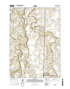
2017 Map of Peoria
USGS Topo · Published 2017About this map
Peoria sits at a critical bend in the Willamette River, where the waterway fractures into a complex network of channels and islands. This landscape is defined by its riparian geometry, with named features like John Smith Island, Centennial Island, and Hoacum Island separated by the Booneville Channel and Albany Channel. The settlement pattern reflects a long-standing agricultural and riverine history, evidenced by numerous family-named cemeteries such as Brattain Cem, Miller - Coon Cem, and Pugh Cem scattered across the fertile bottomlands between the river and the meandering Muddy Creek. The transition from river-based transport to modern aviation is marked by the presence of Schrock Airport and Jim's Airstrip. Extensive sloughs and bends, including McBee Slough and the evocatively named Snag Boat Bend, illustrate the dynamic nature of this floodplain on the Benton and Linn County border.
Find a feature on this map
77 named features on this map. Tap any name to fly to it.
Don’t see what you’re looking for? This feature index may not catch every label — zoom into the map to look around manually.
Map Details
Editions of this 2017 Peoria Map
This is the sole edition of this map. No revisions or reprints were ever made.
Other maps of this area

1909 · Harrisburg
USGS Topo · 1:31,680

1909 · Rowland
USGS Topo · 1:31,680

1911 · Monroe
USGS Topo · 1:31,680

1911 · Tangent
USGS Topo · 1:31,680

1911 · Inavale
USGS Topo · 1:31,680

1912 · Halsey
USGS Topo · 1:62,500

1913 · Philomath
USGS Topo · 1:31,680

1913 · Oakville
USGS Topo · 1:31,680

1916 · Albany
USGS Topo · 1:62,500

1921 · Corvallis
USGS Topo · 1:62,500