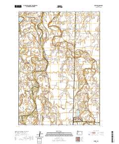
2020 Map of Peoria
USGS Topo · Published 2020About this map
The Willamette River meanders extensively through this portion of the Willamette Valley, defining a landscape of complex waterways and island formations. The community of Peoria sits on the eastern bank, positioned near where McBee Slough and Muddy Creek converge toward the main river channel. This environment is characterized by numerous named bends and islands, including Snag Boat Bend, Jacobs Bend, and Hoacum Island, reflecting the shifting nature of the river over time.
Find a feature on this map
81 named features on this map. Tap any name to fly to it.
Don’t see what you’re looking for? This feature index may not catch every label — zoom into the map to look around manually.
Map Details
Editions of this 2020 Peoria Map
This is the sole edition of this map. No revisions or reprints were ever made.
Other maps of this area

1909 · Harrisburg
USGS Topo · 1:31,680

1909 · Rowland
USGS Topo · 1:31,680

1911 · Monroe
USGS Topo · 1:31,680

1911 · Tangent
USGS Topo · 1:31,680

1911 · Inavale
USGS Topo · 1:31,680

1912 · Halsey
USGS Topo · 1:62,500

1913 · Philomath
USGS Topo · 1:31,680

1913 · Oakville
USGS Topo · 1:31,680

1916 · Albany
USGS Topo · 1:62,500

1921 · Corvallis
USGS Topo · 1:62,500