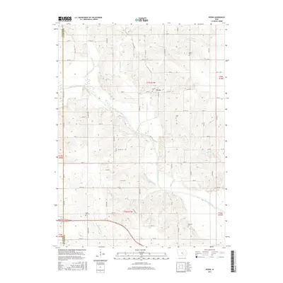
2015 Map of Peoria
USGS Topo · Published 2015About this map
Peoria anchors this rural landscape along the border of Mahaska and Marion counties, where the South Skunk River carves a broad valley through the Iowa farmland. The settlement pattern is defined by a dense network of county roads, including Co Hwy G57 and Co Hwy G15, which serve the agricultural interior. Numerous family and community burial grounds, such as Baldwin Cem, Appel Cem, and Centennial Cem, are scattered across the townships, providing significant touchstones for local genealogical research.
Find a feature on this map
44 named features on this map. Tap any name to fly to it.
Don’t see what you’re looking for? This feature index may not catch every label — zoom into the map to look around manually.
Map Details
Editions of this 2015 Peoria Map
This is the sole edition of this map. No revisions or reprints were ever made.
Other maps of this area

1910 · Pella
USGS Topo · 1:62,500

1912 · Pella
USGS Topo · 1:62,500

1954 · Des Moines
USGS Topo · 1:250,000

1956 · Des Moines
USGS Topo · 1:250,000

1957 · Des Moines
USGS Topo · 1:250,000

1968 · Oskaloosa
USGS Topo · 1:24,000

1969 · Des Moines
USGS Topo · 1:250,000

1979 · Searsboro
USGS Topo · 1:24,000
1980 · Leighton
USGS Topo · 1:24,000

1980 · Sully
USGS Topo · 1:24,000